NewDJI EnterprisePayloads

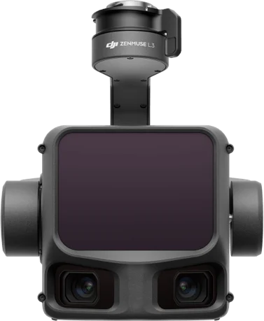
DJI Zenmuse L3

Product overview

The DJI Zenmuse L3 is DJI's first long-range, high-accuracy aerial LiDAR system, mounted on the Matrice 400. It combines a 1535 nm LiDAR, dual 100 MP RGB mapping cameras and a precise POS system in one unit. Built for survey mapping, topography, infrastructure surveys and digital twins.

Laser wavelength
1535 nm
Max range
950 m (10% reflectivity, 100 kHz)
Max pulse rate
2 million points/s
Returns
up to 16

Made to order, 2–3 weeks

  • 12-month official warranty
  • Invoices for companies
  • Operator training at handover
Brochure in Mongolian (PDF)
  • Long-range LiDAR: the eye-safe 1535 nm laser detects even low-reflectivity surfaces from far away
  • More area per flight: flying higher cuts job time sharply, covering up to 100 km² a day
  • Sees through vegetation: multiple returns reliably find ground points even under dense vegetation
  • Dual 100 MP RGB cameras: mechanical shutters and a wide field of view capture true-color imagery together with the point cloud
  • Star-shaped scan mode: balances accuracy with coverage from multiple angles
  • Improved POS system: microsecond-level time sync for high-accuracy positioning
  • Real-Time Terrain Follow: holds a steady height along the terrain
  • Suited to power line inspection: renders thin objects at high density
  • Complete workflow: process in DJI Terra with no extra license, and pair it with the D-RTK 3 station
  • Standard outputs: LAS, LAZ, E57, GeoTIFF, DEM

Brochure in Mongolian

Specifications and features translated into Mongolian, as a PDF.

Talk to a sales engineer

We help you choose equipment and arrange quotes, demo flights, operator training and service.

Request a quote

Leave your number and a sales engineer will call with pricing and training details.

We only use your details to answer this request.